If you’ve ever found yourself at sea or planning a voyage, knowing how to interpret marine weather radar is crucial for your safety and voyage planning.
What Is Marine Weather Radar?
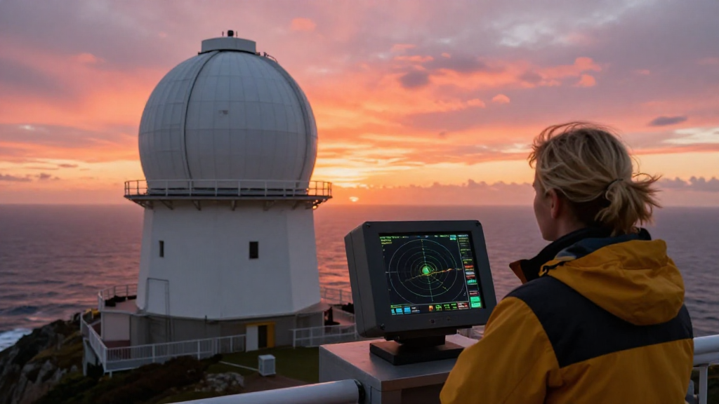
Marine weather radar is a critical tool for mariners that allows them to observe weather conditions surrounding their vessels.
This technology uses radio waves to detect precipitation, wind patterns, and other meteorological phenomena.
Understanding it can help in making informed decisions while at sea.
To effectively utilize marine weather radar, one must grasp the following concepts:
- Rain intensity
- Storm tracking
- Wind direction and speed
Why Is It Important to Know How to Interpret Marine Weather Radar?
Understanding how to interpret marine weather radar can help you:
-
Avoid Dangerous Situations: With accurate forecasts, mariners can steer clear of storms or other hazardous weather conditions.
-
Optimize Navigation: Proper interpretation allows for more efficient route planning, saving both time and fuel.
-
Enhance Safety: Real-time awareness of changing weather patterns ensures that you can react promptly to new developments.
What Are the Basics of Marine Weather Radar?
To get started, you need to familiarize yourself with some fundamental aspects of marine weather radar:
-
Range: This indicates the distance the radar can detect precipitation. Most marine radars have a range of anywhere from 0.125 to 96 nautical miles.
-
Scan Mode: Different scan modes can offer varying levels of detail. Continuous scanning may provide more insight into rapidly changing weather.
-
Color Codes: Most radar displays use color coding to indicate the intensity of precipitation, typically:
- Green: Light rain
- Yellow: Moderate rain
- Red: Heavy rain
- Pink/White: Severe storms or hail
- Echoes: These represent the reflected radio waves and can vary in brightness depending on the intensity of precipitation.
How to Read Marine Weather Radar Data?
When learning how to interpret marine weather radar, it is essential to know how to read radar images accurately:
-
Identify Precipitation Areas: Begin by locating the areas displaying echoes on the radar.
-
Assess the Intensity: By observing the color codes mentioned above, determine the intensity of precipitation.
-
Evaluate the Movement: Note the direction and speed of storm systems. Moving echoes indicate shifts in weather patterns, which you’ll want to track actively.
-
Look for Patterns: Pay attention to patterns in the data, such as squall lines or development of new storms.
-
Consider the Time: Old echoes can be misleading. Make sure you are viewing the most current data.
What Advanced Techniques Can Help You Interpret Radar Data?
Once you are comfortable with the basics, consider the following advanced techniques:
-
Dual-Polarization: This technology can differentiate between raindrops and ice particles. Understanding the difference is vital because it affects how you prepare for incoming weather.
-
Integration with Other Data Sources: Combine marine radar data with satellite imagery and weather forecasts for the most accurate picture of upcoming conditions.
-
Radar Reflectivity Maps: These maps provide a more detailed look at precipitation types and levels. Familiarize yourself with how to access and interpret these maps.
Common Pitfalls When Learning How to Interpret Marine Weather Radar
Many mariners face issues when interpreting radar data. Avoid common pitfalls like:
-
Ignoring the Past: Always consider previous weather patterns when future conditions appear to be changing dynamically. Trends can offer insight into what might happen next.
-
Underestimating Small Storms: Small echoes don’t mean small storms. Always remain vigilant and don’t let size lull you into complacency.
-
Misreading Color Codes: Different radar systems may use slightly different color schemes. Always confirm what colors represent what types of precipitation.
-
Not Paying Attention to Wind: Wind patterns can significantly impact storm development and movement. Monitor for wind direction and speed alongside the radar data.
How to Use Marine Weather Radar for Route Planning?
When planning your route, using radar data adds a layer of security. Here’s how you can do so effectively:
-
Review Current Radar Conditions: Analyze the latest radar images to identify areas of precipitation or storms.
-
Check Forecasts: Look ahead at the forecast to see if conditions are expected to worsen.
-
Identify Safe Zones: Use the data to plot routes that allow you to steer clear of dangerous areas, including nearby landmasses or shallow waters.
-
Communicate With Others: Share insights from radar interpretations with your crew, ensuring everyone is on the same page regarding safety procedures.
-
Adjust Plans as Needed: Remain flexible in your navigation plans, adjusting as radar data updates occur.
Conclusion: Mastering Marine Weather Radar
Knowing how to interpret marine weather radar is an indispensable skill for any mariner.
As you develop your expertise in reading and analyzing radar data, you’ll become more competent in making safe and informed navigation decisions.
Remember to continually refine your skills by practicing with real-time radar and staying updated on new technologies in marine meteorology.
With these steps and practices in hand, you’re on your way to mastering marine weather radar and ensuring a safer voyage, regardless of the conditions.